
Extracts from:
The King's Highway in Craven
Being Notes on the History of the Yorkshire Portion of the
Keighley and Kendal Turnpike Road
by John J. Brigg (1927)
In the days before railways, a main road, leading from busy and populous towns into remote country districts, was comparable to an artery along which the products of commerce and manufacture were carried into thinly peopled areas in exchange for the produce which the towns were less able to produce for themselves. With the coming of the railway the highways lost much of their importance, and roads which had once been thronged with carts and carriages fell more or less into disuse. Thirty years ago it was not uncommon to see half the width of a main road, which in its day had been crowded with vehicles, no longer kept in repair. This was particularly evident in the Great North Road.
The introduction of mechanical road-transport has restored to old roads much of their former importance, and many roads which had fallen into partial disuse are now busy as of old. To trace such vicissitudes and try to explain them by historical facts is an interesting study, and any old English road which has long maintained a regular communication between manufacturing centres and agricultural districts is worth attentive study. I have chosen the Keighley and Kendal Turnpike Road because it is one that I have known all my life and because I have had the opportunity of studying its history in the the minute-books of the trustees. I have confined my inquiry to the Yorkshire section of the road.
From time immemorial the duty of repairing the highway had fallen upon the inhabitants of the parish (in Yorkshire the "township") through which it ran. The Highway Act of 1555 re-enacted this customary liability, and, further, provided that all the inhabitants above the position of a hired labourer were to come together with horses and carts and give their labour for six days in the year to repair the roads. ... In 1706 we have the first instance of a "Turnpike Trust," when a body of private persons were appointed to manage a highway between Fornhill in Bedfordshire and Stony Stratford in Bucks. This was the beginning of the great system of Turnpike Trusts and Turnpike Roads, which increased so enormously that eventually twenty-three thousand miles of English roads were managed in this way.
The Turnpike system has so completely faded from memory that it is necessary to recall the fact that its original purpose was to keep in repair the existing roads rather than to make new ones. The commonly held idea of a Turnpike Trust is that the trustees laid out and made the roads, just as our railways and canals were made, and then proceeded to levy exorbitant tolls on those who used them. What really happened, in most cases, was this. By private Act of Parliament the maintenance of an existing highway was entrusted to the management of a body of trustees comprising most of the landowners and people of standing along the line of the road. They were empowered to set up toll-gates and levy certain specified tolls on all users of the road, and from theses tolls they had to keep the road in good repair.
THE EARLY HISTORY OF THE TRUST
Shortly after 1750 there was a movement, in this part of Yorkshire, for putting the highways under Turnpike trustees, and in 1753 the private Act was obtained for the road between "Keighley in the Westriding of Yorkshire and Kirby in Kendal in Westmorland." It was an important highway between the manufacturing districts of Yorkshire and Westmorland, not only for the exchange of agricultural produce and manufactures, but also for the traffic in half-manufactured material such as combed wool sent to be spun in the farm houses and villages, or warp and weft for the handlooms.
In the Act, a great number of gentlemen are appointed trustees, and about forty of them attended and "qualified" at the first meeting, which was held at "the dwellinghouse of Robert Johnson in Settle," but all through the history of the Trust a few trustees did all the work, and these mostly from the Settle district. Well-known names, such as Farra, Ingilby and Birkbeck constantly occur, though at a later date Mr. Garforth, of Steeton Hall, and Mr. Greenwood, of the Knowle, Keighley, were active trustees.
BRIDGES
Steeton Bridge
yards between the springers, the battlements to be three-quarters high above the pavements and well secured with iron clamps." John and William Redmayne, Timothy Moorhouse and John Sugden agreed to build it for six guineas and some of the old materials. The trustees at the same time decided that the road should run "on the way now used" i.e., by the existing road and not by the alternative one which, as Dr. Villy has pointed out, branched from Steeton Bank, and crossing the beck above the bridge ran out by the still-existing Wood Street into Hob Hill Lane.In 1753 a bridge was built over the beck in Steeton village at the foot of Steeton Bank, "in the place where the old one is." It was to be "6 yards wide with the battlements, 4½
PURCHASES OF LAND
... examples of purchase of land are:-
1754 - Steeton, from John Baynes Garforth, "Wilson's Croft" at £50 per statute acre. Steeton, from John Baynes Garforth, "Braceletts" at £25 per statute acre.
THE TOLLS
The Tolls system, with its Toll-bars, Toll-farmers and Turnpike-men was the most characteristic and best remembered feature of the turnpikes, besides being the principal source of revenue for the trustees, but it was a system difficult to manage and open to much fraud and peculation. The trustees of our road tried, at first to collect the tolls by their own servants, paying the gatekeepers £10 a year and expecting them to be on duty from 4 a.m. to 11 p.m.! No wonder the system was abandoned after a short trial period...
A DESCRIPTION OF THE PRE-TURNPIKE ROAD.
Anyone standing on the top of the hills near Keighley, and looking to the North-west, will remark how the Malham Fells sink down into a series of low-rounded hills forming an easy approach from this part of Yorkshire into Westmorland. Beyond this gap in the Pennine Hills the Lake Mountains are visible, and it has always formed an easy road from the north-west into Yorkshire. By this route the Tenth century Norsemen came down from Cumberland, leaving traces of their presence in some of the place-names, and in the pre-Norman churchyard crosses of the Aire Valley, and that such an obvious route should be utilised by the Romans for a military road is highly probable. Dr. Villy, of Keighley has found traces of two such roads, viz.:-
From Keighley by Hollins Lane, Steeton, Eastburn, Cross Hills and over Glusburn Moor to Elslack, and perhaps forward to Paythorne across the Ribble.
From Ilkley to Skipton, and thence by Gargrave, Coniston Cold, Hellifield, Long Preston, Settle, and Clapham, following pretty closely the road we are about to trace.
Between Cross Hills and Skipton there is a gap of about five miles, and the guess may be hazarded that in mediæval times these two roads were linked up by a track for which the fourteenth-century bridge at Kildwick was built. Whether this be so or not the old Keighley and Kendal road was for several centuries an important highway. Most of it still remains, and it is well worth the while of anyone who does not mind a rough and hilly track to follow the old road for the sake of the views to be obtained. As William Cobbett long ago remarked, "Those who travel on turnpike roads know noting of England." The most notable views are those from Steeton Bank, Hamblethorp near Bradley, Long Preston Moor, Buckshaw Brow, and from the old Clapham-Ingleton road.
About 1720 John Warburton (see Yorks Arch Journal, Vol xv., p.61) was collecting material and making surveys for his great map of Yorkshire ... An abbreviation of these notes with comments of my own will serve as a description of the old road in its course from Keighley to Skipton.
... Descending the steep "Bank" into Steeton the road crossed the beck and ran, as it does now, in front of Hob Hill, and so direct to the beginning of Harewood Hill. Here it made a right-angled turn down to a place afterwards called "Nanny Grave Hill" (after some poor suicide buried at the cross-roads), and so, turning left, by Lyon House - "Ye Red Lyon Inn," of Warburton - to Easturn Bridge - "cross Eastburne beck a stone bridge."
This is an old bridge. In 1642 it was reported to Quarter Sessions:- "That there is and hath been time out of mynde a bridge called Eastburne bridge with the parish of Kildwicke in Craven, in the high streete or roadway between London and Kendal for all passengers and travellers who continually do travel that way with packes and other carriages."
THE MAKING OF THE MODERN ROAD
Having described the road which was put under the charge of the trustees by the Act of 1753, we have now to record the steps by which their zeal and enterprise converted that mountain-track into the present highway.
KEIGHLEY TO STEETON, 1782

In this year the steep descent into Steeton called the "Old Bank" was superseded by the road from Utley Green Head under Hawkcliffe Wood, now known as "Old Bar-house Lane." As it was necessary to close an existing highway, the consent of the Quarter Sessions had to be obtained, and we thus have details preserved of a scheme, the record of which is nowhere else to be found. In the Quarter Sessions Order-book, preserved at Wakefield, under the year 1782, it is stated that a certificate was produced signed by Henry Wickham and Johnson Atkinson Busfield, Esquires, to the effect that they had viewed:-
"A certain Bridleway leading from a certain place called Dark Lane Top through Utley in the township of Keighley to a certain place called Dog-Kennel within the township of Steeton containing 2 miles 6 furlongs 35 roods or thereabouts, as shown on the plan annexed, and also viewed part of a certain Turnpike Road leading from the Town of Keighley to Kirkby in Kendal in the County of Westmorland to wit from the Dark Lane Top to Utley Green head through Hawkcliffe to Steeton, lately made at great expense for the conveniency of travellers, and also a certain highway from and through Steeton to Dog-Kennel, containing 2 miles 5 furlongs 30 yards and the breadth of 30 feet or thereabouts as shown on the plan annexed."
The certificate goes on to say that the two justices find that "the said Bridleway is not only dangerous in many parts thereof to passengers and that the new road through Hawkcliffe is both nearer and more convenient to the public."
It was ordered:-
"That the said Bridleway may be diverted and turned into the said Turnpike Road from the Dark Lane Top to Utley Green Head, and from thence into the said new Road through Hawkcliffe to Steeton and from thence into the said Highway through Steeton to the Dog-Kennels, reserving to the landowners of land adjoining upon the said Bridleway a free passage for persons horses cattle and carriages on the said Bridleway in and from their several lands and grounds adjoining thereto according to their ancient usage; and we hereby further order that that part of the said Bridleway to wit over a certain close of land in Steeton township which belongs to Thomas Cowling called Cowling Intake (containing 255 yards or thereabouts) as described in the plan, be stopped. All ancient rights to be excepted."
The plan which accompanies this order is of interest to Keighley readers of this paper, as it shows the complete course of the old road, the southern portion of which was the once well-known "Dark Lane." I will try, in the absence of a plan, to describe it. reminding my readers that the present "Skipton Road" was not yet made. I use modern place-names.
"Dark Lane Top" is where Holly House stands, and from there "Dark Lane" proper ran across the park of Cliffe Castle and Beechcliffe House grounds. From this point it dipped in a loop below the present Skipton Road and rising along the line of the existing street reached the Cemetery gates. When the Cemetery was made the old lane was diverted to its present line outside the walls, but originally it ran diagonally across the cemetery site to Low Utley. It is represented by the present footpath running past Dawslack and across the railway through the Ings (where "Cowling Intake" was situated) to Steeton Station. There is a lane alongside the line to the South of the station which seems to be a diversion of the bridleway which crossed the present road and terminated at the small building at the northern end of the Steeton Hall rookery, still known as "the Dog Kennels."
The roads in Steeton will, for convenience and clearness, be described in an Appendix.
It is not easy to realise that before the great thoroughfare from Keighley to Hawkcliffe was laid out in 1825 the only direct road to Utley (and that a bridle-road only) was this narrow, winding track, while carriages were obliged to go round by Utley Green Head. The old bridle-way was a pleasant road through the fields to Utley and Steeton, and it had the additional recommendation of avoiding a toll-gate. The trustees, having spent so much money on making the road from Utley Green Head to Hawkcliffe, and from there to Steeton - high retaining walls having to be built over part of the course - were naturally anxious to close a competing road; hence the above order. Dark Lane was finally closed by the Keighley Corporation Act of 1891.
What is known to-day as the "Old Bar-house" was no doubt built at the same time on the new line of road. In 1788 there is a minute of a decision to pull down the old turnpike house at the foot of the Bank in Steeton, and the gate there erected is ordered to be kept locked to prevent passengers going upon the old road, every occupier of land to have a key delivered to him by Mr. Garforth. Dr. Rowe, of Bradford, points out a clause in the "Enclosure Act for Steeton and Steeton Moore, 1797," which seems to bear on this point, but, as the Award Map is missing we cannot be certain: "And whereas the Highway formerly leading over the Moor called Steeton Moor from Steeton aforesaid to Keighley is now vested in and become the property of Joseph Edwards, gentleman, the highway named is to be considered as part of the Commons to be enclosed and Mr. Edwards is to be compensated." I am not quite clear what this clause implies in law.
Carey's "English Atlas," 1793, mentions the view from Steeton bank, but, as described above, travellers had by that time exchanged the wider view for the easier gradient.
STEETON TO EASTBURN BRIDGE, 1789
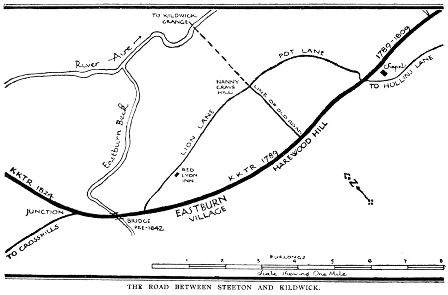
As already stated, the old road followed the line of the present highway from the Wesleyan Chapel to the top of Harewood Hill, where it turned down into the fields to a cross-roads called "Nanny Grave Hill." Here a lane led back to Steeton (the present "Pot Lane"), a lane went forward across the river to Kildwick Grange, while the main road went to the left past the "Lion" to Eastburn Bridge. This curious line of the old road was first pointed out to me by Dr. Villy, and it is fully confirmed by Ogilby and Warburton. In laying out their new road, the trustees adopted the direct line through Eastburn - the line of Dr. Villy's Roman road - and made the present road from the Wesleyan Chapel to Eastburn Bridge.
I have no direct evidence of the date of the road through Steeton from the Goat's Head Inn to the Wesleyan Chapel; it may have been made at this time, or along with the Hawkcliffe improvement of 1782, or, again, in 1809, when, as we shall see, another turnpike received "running powers" over ours.
The portion of the old road between Harewood House and Nanny Grave Hill was sold to Mr. Garforth in 1801, the boundaries being described as "East and West other lands of Mr. Garforth and Mr. Rishworth - North a lane called Pot Lane, and South the present turnpike road." Eastburn village which, before 1789, lay off the main road has adapted itself to the change, but the old "Red Lyon Inn" of Warburton was hopelessly side-tracked. The licence and the name were transferred to Eastburn, but the old name is kept up in "Lyon House".
There was an inn at Cross Hills - the present "Old White Bear," and in 1825, when the present road from the Junction to Kildwick Bridge was made, the landlord, James Slack, thinking his trade would suffer, removed to the "Red Lion," at Eastburn and re-named it the "White Bear." The present front building of this "White Bear," at Eastburn was erected at the same time, while the old "Red Lion" buildings still remain at the back. See John Clough's "History of Steeton."
COLNE AND ADDINGHAM ROAD, 1809
This road, for part of its length, formed part of the Keighley and Kendal road, and in 1809 the Colne and Addingham trustees gave notice of their intention to apply for powers to divert their road, "which said diversion will include part of the Keighley and Kendal road between a place called Cross Hills and Steeton." The trustees of the latter road stipulating for a clause prohibiting both bodies of trustees from erecting a turnpike gate anywhere "between Farnhill and the end of Steeton." This clause was evidently agreed to, for we find so late as 1855 that permission to alter it was refused.
One portion of the road under discussion is the length between the Goat's Head Inn in Steeton and the Wesleyan Chapel. I have no direct evidence as to when it was made, but it must have been a part of the Colne and Addingham road. Some kind of road is indicated in Warburton's Notes and map, and the Quarter Sessions' plan of the Hawkcliffe improvement in 1782 marks it as "the road to Skipton." The bridge or large culvert would probably be erected in 1809.
The Colne and Addingham "Diversion" referred to above is the present fine road from Colne over Reedshaw Moss and running through Cowling, Glusburn and Cross Hills. The old road (the subject of an Act obtained in 1755) ran from "Blue Bell" near Colne through Black Lane End over the hill past Cowling Hill, Carr Head, and Malsis to Glusburn. It crossed the stream above Glusburn, by a bridge (rebuilt 1914) which became the subject of a well-known "leading case" in the Law courts, when it was held that a bridge built for the public convenience and serving a public need is to be maintained by the County authority although they may not have been consulted in the building of it. In 1826 the same trustees carried the road forward from Steeton through Addingham and Ilkley called Cocking End, where the old road from Silsden terminates. The name of the Trust had been changed to the "Blackburn, Addingham and Cocking End."
For nearly twenty years after 1804 the trustees undertook no works of improvement, but when their Act was renewed in 1823 (at a cost of £835 5s. 11d.) four intended pieces of work are named, viz.:-
From "the Flosh" in Keighley to Hawkcliffe.
Across Coniston Moor.
From Eastburn Bridge to Kildwick Bridge.
From Clapham to West Houses.
KEIGHLEY TO HAWKCLIFFE, 1824

The fine approach to the town of Keighley from the north was commenced in 1824 and reported finished in 1826, when it was stated that the works had "stood well and given general satisfaction, although much delayed by the delay in the proceedings and the frequent occurrence of re-letting." The new road begins at the "Flosh" at the bottom of Spring Gardens Lane and runs due north to a place formerly known as "The Friendly Oaks" from two oak trees which grew there. It may be remarked that here, in what is one of the main street of a considerable town, the view in both directions ends in a fine hill top - Cradle Edge above Hainworth to the south and Pinfold Hill (Robin Hood's Stone) to the north. From "The Friendly Oaks" the road follows a level contour, cutting across the remains of "Dark Lane" described above, through Utley to the junction with the 1782 road at the beginning of Hawkcliffe Wood.
The contractors for the work were John Steward acting with David Davies, William King with Thomas Tillotson and Joseph Binns, and the prices paid varied from £4 19s. 6d. per rood. The land required was valued by Mr. Ayrton at £918 2s. 3d. with the note: "This sum is large in consequence of a great part of the land being valuable on account of its adjoining so near the town of Keighley." One would have thought that landowners might even have given land for a road which was to be made at no expense to themselves and to the great improvement of their property.
The trough opposite Rose Cottage bears the incription, "K.K.T.R., 1825"; the only dated piece of work on the road so far as I know. The burr or retaining wall beyond Utley caused further expense by giving way, and there is a note in 1832 that the wall on the lower side of the road between Hawkcliffe and Utley is being continually thrown down and the surveyor is ordered to put a coping on it if the proprietor of the land will lead lime and materials. The County Council are still to-day replacing these coping-stones thrown down the hill by mischievous boys. It is interesting to note the use of new materials, engine-ashes are to be rolled in with the usual gravel, and the trustees are strongly recommended by their committee to continue the use of limestone, particularly on this piece of work, "being well convinced it will ultimately prove the cheapest, though at first expensive, and that winter should not be allowed to pass over without a considerable portion of the whole having a slight coat laid upon it, in which case little or no labour would be required during the whole of next summer." It was also decided to purchase an iron roller 4ft. in diameter.
EASTBURN BRIDGE TO KILDWICK BRIDGE, 1824
This improvement, cutting off the circuitous route by Cross Hills was also begun in 1824. It diverges from the old road at the "Junction," and runs practically straight and due north to Kildwick Bridge. Mr. Holgate made the plans, including the necessary alterations to each bridge, and the surveyor's estimate of the cost was £890. The tenders were:-
Wade and Chippindale, £1,020; Hiram Craven. £1,450; Townend and Bolton, £1,098; John Stirk, £680.
Someone (probably the clerk) comments very feelingly thus:-
"Of course the last was accepted. During the progress of the work Mr. Craven, in whose judgment the Committee place great confidence, declared it was impossible to do the work done by Stirk for less than his (Mr. Craven's) offer."
(No doubt Mr. Craven was right; he was a contractor of some note, a native of Oakworth, and built the new Ouse Bridge at York. Mr. Stirk was eventually paid £1,032 13s. 1½d.)
Near Kildwick Bridge the road is carried on land-arches and that part of the fence-walls is finished with very heavy round copings.
In 1878 the Keighley and Kendal Turnpike Trust expired, and the road they had so long controlled was "disturnpiked." By the "Highways and Locomotives Act" of 1878 all roads disturnpiked since 1870, that is to say, most of the principal roads, became "main roads," and the cost of maintaining them was ordered to be shared equally between the district through which they ran and the general body of County ratepayers as represented by the magistrates for the County, meeting in Quarter Sessions.
A new era of assistance and control by the Central Government seems to be commencing, and further improvements to the "arterial" roads (to use the current phrase) we have been describing may be looked for. The Ministry of Transport may be grateful to the old trustees that in the matter of lay-out of the road so little remains to be done.
APPENDIX I.
THE ROADS BETWEEN STEETON AND ADDINGHAM.
Standing at the top of Station Road in Steeton it will be noticed that the row of old houses on the West side of that road is not in line with the present road. The explanation is that they follow the line of the former road, part of the highway (a turnpike) from Colne to Addingham. Collating the information contained in the plan attached to the Quarter Sessions Order of December 22nd, 1781 (when the road into Steeton under Hawkcliffe was made) with that contained in Mr. John Clough's "History of Steeton" (founded partly on Mr. Jonathan Hindle's notes), we may reconstruct the former roads in the following manner:- The road from Colne came into Steeton village as it does now and served as a Northward continuation of the road from Keighley. It is not known when the bridge across the beck was built, but Mr. Clough states that it is shewn in the "Original Survey of all Bridges in the Riding," by Westerman & Gott (does this refer to the old bridge at the foot of Steeton Bank?) Turning North at the Star Inn the road ran through what are now plantations, close past the end of the Hall stables to the building still known as the Dog-Kennel. From this point the 1781 plan gives a "bridlestyle" to Silsden. This road crossed the river by a bridge which had been repaired in 1642 and again in 1681, it stood near where Steeton Beck enters the river and the stones of the foundations may be seen in the bed of the river. This footpath to Silsden was diverted in 1802.
The main road to Silsden (Called "cart road" in the plan) turned at the Dog-Kennel sharply to the right towards the present railway crossing, being at the same time part of the old bridle-road through the Ings to Utley, and somewhere near the railway crossing turned again to the left and ran forward to Silsden. The river was formerly crossed by a ford at a place called "The Streams," a little above the present bridge. "There was a sod in the river at the ford, if the sod was covered with water it was unsafe to cross and carts laden from Ilkley, Otley, Wharfedale, etc. (it is said that Steeton was supplied from Otley with flour in those days), had to go round by Kildwick Grange and Kildwick. In 1784 a wooden bridge was built by the township with some help from the County "according to the plan of Mr. Hartley, the surveyor, the estimate being referred to Mr. Garforth, Rev. Charles Knowlton, Mr. Wickham and Mr. Busfield, justices of the peace, to contract with workmen for building the same." This (the present) bridge was opened in 1804, Mr. Benjamin Muschamp was the builder and the cost £3,529 7s. 10¾d. The line of this carriage-road through Silsden is fixed by the canal bridge and it went out of the village by the Back Lane (the Cringles Road not being then made) past the Tannery and over Brown Bank to Cocking End on the present Addingham-Ilkley road. This road was part of the first Colne and Addingham or Blackburn, Addingham and Cocking End Trust. Some of the early contracts were carried out by "Blind Jack of Knaresborough." At the top of the hill the present Turner Lane represents what was once the only road from Silsden to Addingham, running down to the Toll-house, crossing the present road and falling into the old road from Skipton over Draughton Moor. We have seen in the text that in 1809 the Colne and Addingham trustees proposed to come through Glusburn and Cross Hill to Steeton, perhaps the Corn Mill bridge was built then. Mr. Clough informs us that the present road from Steeton to the river was made in 1826 or 1828 and perhaps the fine Cringles road was made at the same time.
APPENDIX III.
TOLL-BARS ON THE KEIGHLEY AND KENDAL ROAD.
These varied in number and situation at different times, and it will be convenient to enumerate them in geographical order from South to North.
Steeton Bar. - This was set up in 1753 at "Steeton Cross," that is, at the foot of the steep hill by which the road then descended into Steeton. In 1782 when the new road under Hawkcliffe was made, the bar was removed to where the cottage now known as the "Old Bar-house" stands. The house at Steeton was ordered to be pulled down in 1788. In 1823, in view of the opening of the new road from Keighley, the New Bar-house" at Hawkcliffe was built, intercepting the traffic by "Old Bar-house Lane" as well as that by the new road. The initials and date (1878) were put up by the purchaser, the late Sir John Horsfall, when the trust was abolished and the houses sold.
The house has had its tragedy. Mr. John Clough in his "History of Steeton" (p. 48) tells us: "In 1861 the man who lived at the toll-bar, named Holdsworth, shot his wife from the bedroom window. His wife and her brother were walking together on the footpath, about thirty yards on the Steeton side of the house, when the shot was fired which killed his wife. It was not certainly known whether he was aiming at her or her brother. He was found hiding on the moors; when he was tried he was brought in insane and imprisoned for life."